The Riverside Commons project was part of Marshall County Crossroad‘s Stellar Region application. Marshall County’s successful designation as a Stellar Region allowed us to use an IHCDA Stellar Set-Aside to successfully obtain tax credits for this project. We still had to obtain every possible point allowed for the sites as set out by the IHCDA QAP, but the set-aside gave us a boost. It’s very competitive for rural LIHTC projects (all of Marshall County is Rural per IHCDA), so the set-aside was critical to receiving this award.
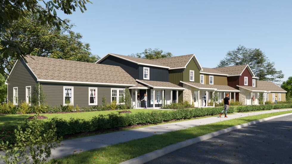
The Paddocks in Culver
We are working on some renderings, but the LaPaz Commons apartments will be all townhomes and look very similar to those we built at The Paddocks in Culver. (See the rendering to the right.) There will be 6 two story townhouses and two accessible flats. There will also be a community room including an administration office and a laundry room. The townhomes will front on Troyer Street, just off Michigan Street. Currently Troyer Street is unimproved, but the Town of LaPaz will be upgrading this street to accommodate LaPaz Commons. The Town has been very supportive and has already brought in some stone to give us an area to get off the road onto Troyer Street.
We are happy to be working with the Town of LaPaz on this project and hope you will come out and help them celebrate this addition to their community.
Last year Culver started a new initiative to replicate the positive steps taken by Marshall County Crossroads with a local version, Culver Crossroads. I have agreed to be involved in several capacities, serving on the Steering Committee & Business Development Committee. There’s the possibility that there will also be a Housing Committee that I would serve on as well. Housing has initially been put under Quality of Life. I’m not sure if that’s going to work or not. I agree the goals are similar, but housing may take some specific focus. In any case, another year, another committee! Lets see if we can make things better.
Rebecca L. Berger, AuD (Dr. Becky) Doctor of Audiology
Just felt like venting a bit on Becky’s behalf. Becky has always loved helping people with their hearing. Her initial degree was in Deaf Education with a minor in Audiology from Ball State University. After several years of teaching, she found that it wasn’t right for her. She loved helping the children, but the administration and bureaucracy was too much. At that point we were living in Georgia. (Did you know that most teachers prepare a lesson plan for their class, while teachers of special needs students, such as deaf students, are required to fill out IEP‘s for each individual student?) We discussed it and she ended up quitting teaching and going to the University of Georgia and getting a Masters Degree in Audiology. Shortly after that we moved back to Indiana and she began practicing Audiology with a group of Doctors. While working with them, she went back to school again, obtaining her Doctorate in Audiology. She studied and understands the theory behind hearing aid technology and the anatomical parts of the ear, how they interact with the brain and how they all are affected by hearing loss.
With all Becky’s education came additional responsibility. As a Doctor of Audiology, she is under different regulations than hearing aid dispensers. She is governed by HIPAA regulations, Medicaid & Medicare regulations and other requirements; things dispensers don’t have to follow.( To be a hearing aid dispenser, there is a test you must pass with the State, but the minimum education is a GED, not a degree, let alone a Doctorate degree.)
The Doctors Becky worked for retired and she decided to go on her own. That was in 2015 when she started Berger Audiology. Less money, but more autonomy and more time to help patients. She invested in the latest technology. She is now the only full time Audiologist in Marshall County. She operates a satellite office in Winamac. But she struggles with the competition. She wrote a 2019 blog post about it here.
Since that time, things have progressively gotten worse. The government has been slowly chipping away at what differentiates an Audiology from a dispenser. On top of that, they are pushing a trend towards Over-The-Counter (OTC) hearing aide sales or even worse, over the internet. You’ve probably seen the ads by Lively which advertise a telephone consultation with an audiologist or worse, My Power Ear, which cites “no need to see an Audiologist” as a positive selling point. She’s seen patients that have bought hearing aids from big box stores, having been sold that they were getting “the latest technology”. In some cases that has turned out to be a generation or two old. Honestly she’s a bit depressed and upset every time one of those ads.
We’re all thrilled with the convenience of the internet and the ability to buy nearly anything you want from Amazon. But is this what we want for healthcare providers? Telemedicine may work for some things like getting a prescription refilled, but does it really replace hands on care? Or in the case of Becky, an Audiologist, how is a phone conversation prescribing a hearing aid equal to her, a trained professional, doing a complete physical examination and doing a hearing test in a calibrated sound booth, using the latest technology? Can they look in your ear an determine that your hearing loss is actually due to wax? Or that the type of hearing loss indicates that you need to see an ENT because there’s the potential for serious issues where hearing loss is just a symptom? Food for thought… or just my rant…
This is a bit of a mini rant today. I’m not sure who it is directed at, but I’m disappointed with the Culver Redevelopment Commission (CRC) and the Marshall County Economic Development Corporation (MCEDC). And probably others for not making things happen and holding MCEDC accountable. For a bit of context for those that don’t know, I was one of the original board members that started MCEDC. For that reason, I feel like its creation is a bit of a legacy thing for me. That’s why I feel bad seeing it in decline over the last several years.
I was pleased when the CRC added funds to support MCEDC a few years back, though I was never a fan of the laundry list approach, where the CRC dictated a list of things that must be done in order to receive those funds. In my opinion it would be better to keep MCEDC nimble and able to address the most pressing needs across the county rather than be encumbered by enumerated requirements. (How this began is understandable, as it was the result of the former MCEDC director’s broken promises.)
This year the MCEDC director met with the CRC to discuss the contract early in the first quarter of the year. An initial conversation was had regarding what should be included with MCEDC to come back with a contract. This never happened.
This is poor performance on the part of MCEDC. An inexcusable and disrespectful performance. But unfortunately, it appears that CRC is looking at this as a cost savings, rather than a lost opportunity. While I didn’t like the way the contract was written, it did provide MCEDC with funds and Culver with MCEDC’s attention.
I’m concerned with MCEDC’s poor performance. I have seen this played out in other communities; not just Culver. I hope the MCEDC board is able to turn this around. MCEDC has been an asset to Marshall County and the communities within it. It is important that it becomes that asset again.
Marshall County Crossroads is coordinating a ground breaking ceremony for Riverside Commons apartments in Plymouth tomorrow, November 2, 2021 at 10:30am. The ceremony will be at the site at the corner of Baker Street and Richter Road on the east side of Plymouth. Marty Oosterbahn will speak for Marshall County Crossroads. Mayor Senter will speak for the City of Plymouth and Kevin L. Berger will speak for Culver Sand Hill Farm LLC and Easterday Construction Co., Inc.
We’re hoping for a good event to kick this project off. This is just for the Plymouth portion of the project which consists of 40 units. We will have a separate ground breaking ceremony next Spring for the second part of this development, consisting of an additional 8 units in LaPaz.
Actual construction should begin quickly with erosion control and earthwork. The first units should be open within 18 months.