Many of you have given me your condolences on the passing of my grandmother. Thank you. I’ve been blessed more than most to have had my Grandma in my life for as long as I did. Not many people live to see their 100th Birthday, which she celebrated in August of 2012. Grandma had 95 very good years before her health began to fail. Even at the end, she was able to smile and enjoy some of the things in life.
The family struggled to put together the obituary (see right); there is only so much that can be said in the limited space. I have a wealth of stories I could tell about my Grandmother, so for those of you interested, indulge me in some rambling memories of some of our good times together.
When I was little, I would spend a lot of weekends with them in their home in Winamac. During a lot of this time she was working at the bank, so Grandpa would entertain me Saturday morning (often watching Saturday morning cartoons with me) until she got home at noon. She and Grandpa woke me in the middle of the night so I could witness some of the Apollo space missions live. They taught me to mushroom hunt. They taught me to fish. Grandma Murphy was probably the only fisherman out on the lake who always had her hair done and was dressed in her good jewelry and full make-up! That didn’t stop her from baiting a hook and taking her own fish off the line though! Grandma had an aging uncle in Monticello she looked after. Grandpa and Grandma would take me with them to do yard work for him on the weekends. Grandma would direct the activities, but would also be right in there working with us.
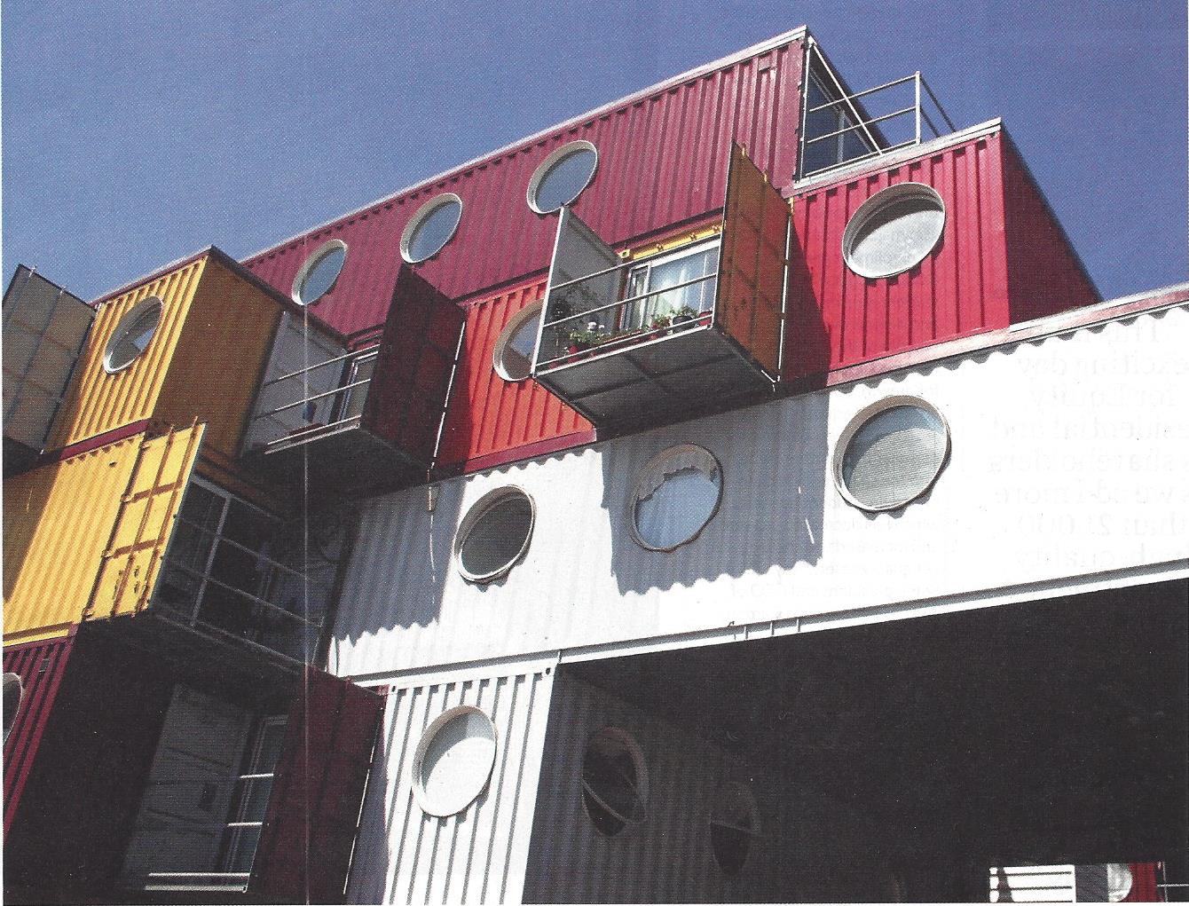
Credit: Urban Space Management (CONTAINER CITY) Ltd.
Brent Martin and I have had several discussions about using shipping containers as living space. Apparently someone beat us on the implementation. London-based developers Urban Space Management used shipping containers to create Container City, a 22-unit modular building. I read about it in the April issue of Multi-Family Executive. You can read the entire article by Linsey Isaacs on their site here. I also read an article recently where Ball State University was experimenting with the idea as housing in third world countries. Another million dollar idea lost to quicker minds…
On Saturday, I sat in on another focus group meeting on the Culver Comprehensive Plan. This one was specific to the Lake Maxinkuckee Environmental Council and Fund. It was a fairly good discussion and several achievable goals were added to the consultant’s list for the plan. I was a little disappointed that there wasn’t more discussion about why goals from the previous plan weren’t met and how to achieve that, but overall I thought it was positive.
The Dream of “Affordable Housing”
As with every single Culver meeting on the Comprehensive Plan that I’ve attended, the subject of affordable housing came up. This is such a nebulous term that is thrown around with people at the table talking about houses currently available in town for $70,000, others talking about the $125,000 to $250,000 range and also the eco-friendly housing project that has been floated around which is looking at the $250,000 range. To help me get a handle on it, I asked a banker friend to break it down. (This is all in big fat round numbers, so don’t get too picky on my math, please!)
The Marshall County Plan Director, Ralph Booker, and Marshall County Building Inspector, Chuck DeWitt, have been working on a system where all of the building permits for the County can be completed through the Marshall County website using the GIS (Graphic Information System). It has been approved by the Culver Plan Commission and was approved by the Culver Town Council at their meeting on February 12th. An issue arose where throughout the County there are multiple properties that are split between a County Zoning District and the various Municipalities’ Zoning Districts. As usual, Culver is the worst case scenario with more split properties than any other Marshall County community. This is a problem since the building permit program would like to address zoning issues in building permit applications via parcel ownership. (You can see a map showing Marshall County and the zoning boundaries of all the communities here.)
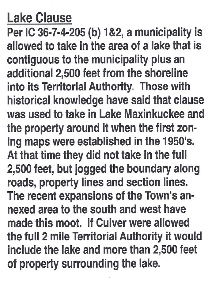
By Indiana State Statute IC 36-7-4-205, municipalities are allowed to take in contiguous unincorporated areas outside of their annexed municipal limits as extended Territorial Authority via their Comprehensive Plan. This is often referred to as the “two mile zoning boundary” as that is the maximum allowed by statute. Even though it is often referenced as the Two Mile Zoning Boundary in discussions at the Culver Plan Commission, and it is labeled that way on the map on the wall, Culver has never had the entire allowed area. In the case of municipalities such as Culver which are adjacent to lakes, the municipality is allowed to take in the lake and the property surrounding it. (See comments on the clause regarding lakes excerpted to the right.)
My understanding is the premise of this statute dates back to the growth spurt Indiana and the rest of the nation experienced after World War II. Often that growth occurred in the fringe areas around municipalities in a chaotic manner. In most cases there was no county zoning at the time, so Indiana and other states granted their municipalities the extended territorial authority to apply zoning standards to the fringe areas. This extended authority varied by state and I found examples of it extending from 1 to 4 miles outside municipal boundaries. In the case of Indiana, most counties have zoning ordinances now, but the extended boundary is still used by communities to control the area of imminent growth at their perimeter. Imminent growth around Culver is probably something that I’ll hear arguments about. In this case “imminent” needs to be judged by the life of our community, not by our short personal lifetimes. Imminent for Culver should be looked at through the lens of the future, looking forward 2o or even 50 years.
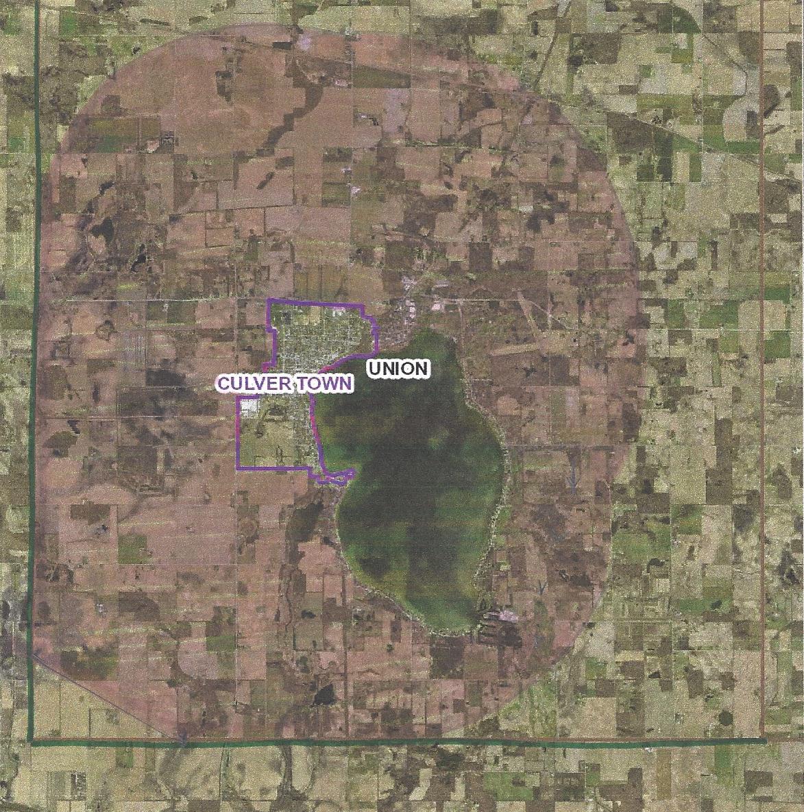
At the time the current zoning boundary was created, Culver was actually pretty progressive and was one of the first communities in Marshall County to establish a Plan Commission and a Zoning District. According to Pete Trone and Bobbie Ruhnow, my planning and zoning historical references, Culver took partial advantage of the territorial authority allowed and included Lake Maxinkuckee in its zoning district. The Plan Commission did not take in the full two miles at the time because they didn’t want to clash with the farm community. Since there was no County zoning at that time, there were no restrictions placed on the farmers outside the municipal limits. In most areas the lines were drawn along section lines or from intersections without regard for parcel lines. Thus the “problem” with the split parcels. This issue exists mainly on the west and north. Parcels were generally used to draw the line around the lake, so the east and south boundaries are clearer. You can see a detailed map of Culver’s zoning boundaries here.
Culver’s Zoning Boundary The pink area shows the current extended authority. The loop outside that shows the approximate limits if the Two Mile area was granted.
In meetings with the Culver Plan Commission, it has been presented that the GIS system at the County is based on the parcel lines and since the zoning boundary lines around Culver do not follow parcel lines, the transitions between zoning boundaries are too difficult to determine. Admittedly, I am no expert in the nuts & bolts of the County GIS system. I am confused though how this can be such a difficult issue when the system currently shows soils maps, flood zones, etc. which bisect parcels and cross parcel lines with curvilinear representation. The current plan is being promoted as “fair” because it takes the majority of the split parcels and puts them completely under Culver jurisdiction if more than 50% is currently under Culver jurisdiction. If less than 50% is currently in Culver jurisdiction the entire parcel will be placed under Marshall County jurisdiction. While this is ostensibly “fair”, fairness is not the reason for the two mile boundary. The two mile zoning boundary is provided for by the State so that a municipality can control its destiny. Theoretically municipalities will continue to grow. Culver should plan to grow! In economic terms, communities are either growing or dying. There is no Status Quo!
Potential Culver Zoning Boundary There area in pink is roughly drawn two miles out from radii at the extents of the Town boundary
Culver currently does not have the full two miles allowed in any direction. So why are we giving up control of any of our current area? Wouldn’t a more prudent solution to the GIS “problem” be to give all of the split parcels over to Culver’s control? While I’m not opposed to following parcel lines for convenience, I don’t think that should mean that we lose any parcel that crosses the current line. With a two mile extended authority our boundary would look more like the drawing to the right. If we take in every parcel that is split by the current boundary, we would still be well within the two mile limit. If that’s not acceptable, then I think the current boundary line should remain as is. As per my reference to the soils and flood plain layers, I think the GIS is versatile enough to illustrate those things. If there’s a discrepancy; bring it to the Plan Commission for a determination.
* Thanks to Pete Trone and Bobbie Ruhnow – both provided historical reference and valuable input to my research.


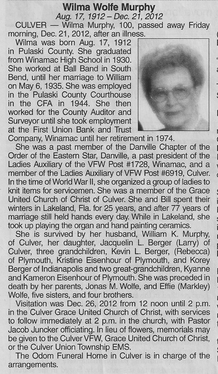 The family struggled to put together the obituary (see right); there is only so much that can be said in the limited space. I have a wealth of stories I could tell about my Grandmother, so for those of you interested, indulge me in some rambling memories of some of our good times together.