Sometimes it takes an outside voice to change things… Rob Hurford with Culver Storage Unit Solutions came before Culver Plan Commission on October 17th to request relief from permit fees on their project. They are building mini storage units on the property west of The Paddocks.
Around 2017/2018, Jonathan Leist, then Culver Town Manager, spearheaded increased building permit fees. The increases were based on what was being charged in larger surrounding areas rather than the cost of services rendered. I protested this at the time, saying they were punitive, unreasonable and comparable fees had been cherry-picked to justify high fees… I was mostly ignored with the argument being presented that the building permit fee was still such a small part of the overall project cost for lake houses and commercial structures that it would not stop construction. I argued that wasn’t the point! The money collected does not go to the plan commission, but to the town’s general fund, i.e. it was a money maker, not a service fee.
The permit fees for the storage unit project were over $17,000. That was partially because the County was requiring each building to be permitted separately, rather than looking at the project as a whole, but also because Culver piled on. These are simple. single story, pole building construction with no water or sewer hook-ups. There will be minimal electrical for lighting. That means that Marshall County’s Building Inspector will have very little to look at and Culver’s Building Commissioner can almost do his job looking at setbacks with a drive-by…
Bass Lake Storage
Mr. Hurford is the Building Inspector for Warsaw, IN. He said in Warsaw, the permit fees would amount to 6% of the Culver fee. They have completed these projects in Winamac and Bass Lake and fees there were less than 15% of the Culver fee.
Culver’s Building Commissioner, Steve Gorski, did a review of permit fees based on costs and has provided the plan commission with revised numbers. These changes were passed on first read and were used to lower the fee for the project to $9k. Still high (and still inflated by the County in my opinion), but much better than the original $17k.
The forlorn fire hydrant that was removed from Sand Hill Farm Apartments
I’m pleased to see that the Plan Commission is taking steps to correct this one. It ultimately falls on the Town Council to make the Ordinance change. Hopefully they follow through. There are other, regressive, junk fees the town charges that don’t reflect services rendered, i.e. private fire hydrants, private fire sprinkler systems, etc. Hopefully this will prompt a review of some of these fees as well.
Just a mini rant… I was a bit upset to find out that the September Plan Commission meeting was cancelled because there wasn’t anything on the agenda. (Per the Building Commissioner) I know it’s a mostly thankless job and that the pay is poor. ($0: They’re volunteers) I was still disappointed that the commission didn’t take the opportunity to catch up on some of the things that they don’t have time for because their meetings are usually busy. Here’s a short list off the top of my head:
The Comprehensive Plan – Most of the Plan Commission has not been involved in the production of the new comp plan, having delegated it to Culver Crossroads. Only one Plan Commission member has been an active Culver Crossroads participant. While the production has been delegated, passing of the plan will still fall on them and this would have been a good time to familiarize themselves with the current draft before the required public meetings. As it stands, they are going to have trouble answering public input questions, since they are not familiar with the new document or the decision making process that went into it.
The Solar Ordinance – They have discussed the need to move this forward quickly as the moratorium passed by the Town Council has left property owners in limbo. This would have been a good time to start assembling names of potential subcommittee members.
The Zoning Ordinance – We have been talking about cleaning up the mistakes from the last go around for several years. Just taking a section at a time in slow meetings would move this forward.
The Dunes – This too will be coming before the Plan Commission as a subdivision request. The planning for this is an important function of the commission.
Related to The Dunes, we are about to start the process of establishing the biggest subdivision (that I know of) since Culver established zoning in the 50’s. I don’t know when the last time the Subdivision Ordinance was updated, but it has been more than 20 years. It references old standards and doesn’t include things like the Complete Streets Ordinance, which was passed 4 or 5 years ago.
Beste Property – The Planned Unit Development zoning district for these parcels has been undone and the property has gone back to its previous zoning designation, S-1. There has been discussion that there should be a change to this, since the property has been annexed. The property is on the market, so giving some guidance to future buyers would be appropriate.
That’s my short list… With a little thought, I’m sure I could double it, but there are hours and hours that could be spent related to the five thing above.
I give volunteers a lot of respect. I’m not going to come down hard on them for taking a breather. But that doesn’t mean there aren’t important things to do.
The Dunes property is highlighted in cyan and yellow. The CabinetWorks property is directly west between The Dunes and S.R. 17
It came to my attention the other day that there are people suggesting that The Dunes not have a street connection to the Town and only connect to S.R. 17 to the west. This seems ludicrous to me, from a planning standpoint, an economic development standpoint and a citizen involvement standpoint. Aside from the bad planning involved with this idea, it is probably a logistical moot point. 1) S.R. 17 is a limited access highway and INDOT is rather jealous with their driveway permits and 2) Cabinetworks owns the parcel to the west between The Dunes and S.R. 17 and are unlikely to want to bisect it with a road. *The picture to the right shows the relationship between the property being developed as The Dunes and S.R. 17.)
Interestingly though, this seems to be a recurring “problem” in Culver. This goes back to at least the early mid 2000’s when The Riggings were initially developed on the north side of town with its street, Anchors Way. At the time of the initial development, the town required a connection to State Street, but later the development was allowed to void that connection. Similarly, there were no connections required between The Riggings and the adjacent vacant property to the west.
The Riggings, is highlighted in yellow. Maple Ridge is the subdivision adjacent to it on the west (left).
West of the The Riggings, the Maple Ridge PUD subdivision was built a few years later. It again does not connect back into Culver, but only connects out to S.R. 10. Maple Ridge was not required to provide any connection points to adjacent properties.
This came up again with The Paddocks with a suggestion that it connect with S.R. 17 in lieu of Jefferson Street. (The Paddocks connects to Culver on Jefferson Street and includes long range plans to connect back to Academy Road to the north.) And then again, the Culver Meadows development proposed on the NW corner of town by Culver Investment Corp (CIC) was allowed to proceed through the primary PUD process with no connections back to Culver.
The Culver Meadows project was particularly troubling since it was allowed to ignore the Culver Comprehensive Plan recommendations for the extension of Academy Road to S.R.17. The reasoning given for not making the connection a requirement was that there were property owners between Culver Meadows and Academy Road that were opposed to the connection. But that is short-sighted. The Town of Culver is theoretically here in perpetuity. Those homeowners will change over time. Culver Meadows should have been required to provide their portion of the required Right-of-Way through their property and Culver could have waited for the right time to make the connection using that Right-of-Way. CIC was already planning a connection to S.R. 17, so it was just a matter of making that connection where it could serve both needs.
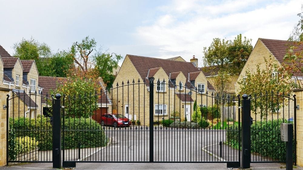
Gated Community
From the developer’s standpoint, these controlled entrances are the next best thing to creating gated communities, but with the benefit of dedicating the streets for municipal maintenance. Theoretically they are reducing traffic in the development to their residents only. This is part of the mindset where we’re seeing more privacy fences and complaints at Council meetings about street traffic. The last drawing I saw for The Dunes has a single entrance and that didn’t even align with adjacent streets. (That drawing is several months old.) There are reasons why towns are laid out on grids and Cul-de-Sac developments lead to more sprawl. (See previous post here.) Grids don’t always work, but the connections are still important.
Connected streets cut down on traffic bottlenecks. What are the residents of The Dunes going to do when street work is required at the entrance? That’s 200 residences with no redundant connection. There is a reason water lines are looped. The same principle applies to streets.
Connected streets promote walking and biking. They invite current residents into the new neighborhoods and vice versa. This is how connections are made. This is where a new resident might get invited to a local Church or civic club. This is how they hear about town initiatives.
Connected streets promote block parties, garage sales and other community involvement activities. The goal of new development goes beyond the head count and ad valorem increase. Culver should want the new residents to become community members. We don’t need more part-time residents and we don’t want to be a bedroom community.
I talked about changing The Dunes’ connections to the town before. (here) I think that idea should be expanded to include additional connections. Make them part of our community for the future. Maybe this is another case made for an Infrastructure Czar… And as far as a connection to S.R. 17? Let’s suggest connection points to the west and south for future development. It’s just good planning.
So, in the past few months, the Culver Plan Commission has rezoned several properties in what they would have considered spot zoning in the past. Two of these were on the main commercial corridors of Main Street and Lake Shore Drive. The first was at 303 North Main Street. This as the former Easterday Dental Office. The Plan Commission rezoned the property from C-2 to R-1 allowing the former residence turned dental office addition returned to residence to receive a permit for remodeling. The second was at 114 Lake Shore Drive. This was a older house used as a triplex. The Plan Commission rezoned the property from R-1 to R-2 allowing the current use to be legal. (They also rezoned 217 South Ohio Street and 810 South Main Street from R-1 to R-2.) I don’t particularly have an issue with any of these uses, but I think they could have been handled better.
303 North Main Street highlighted in the lower left
The property on North Main Street is probably the most problematic to me. The Main Street corridor from the current Main Street business district north to Lake Shore Drive has been designated “Commercial” in the last two Comprehensive Plans. This has been followed up with a zoning district designation of C-2 in the Culver Zoning Ordinance. This has allowed the existing homes to remain, “grandfathered” in their current use; thus allowing the house at 303 North Main Street to be used as a dentist office, the house at 307 North Main Street to be used as a residence & art gallery, the house at 313 North Main Street to be used as a beauty parlor with second floor apartments, and the house at 212 North Main Street to be used as a law office with second floor apartment. This also allowed the expansion of Good-To-Go into the adjacent lot to the north without issue a few years ago.
Culver Comprehensive Plan – Future Land Use & Development Plan, Page 45
In the case of 307 North Main Street, there was no issue when the owners of the art gallery sold the property and the new owners returned the use to residential only. The problem occurred with 303 North Main Street when the new owners wanted to use the property as a home (allowed), but also wanted to remodel. Remodeling required a building permit and residential use is not allowed in a C-2 district. The solution proposed by the then Building Commissioner and accepted by the Plan Commission was to rezone the property as R-1. When it was brought up that this violated the direction of the Comp Plan, the Comp Plan’s recommendations for this area were questioned. I felt the rezoning was a mistake and that considering rezoning that corridor would just compound that mistake. For one quick example, the Rezoning of 303 North Main Street to R-1 placed a buffer restriction that will be imposed if anything is done with 307 North Main Street: “Any property line abutting said residential district shall be required to be effectively screened in one of the following ways, or a combination thereof: buffering by a dense strip of natural plantings or by a solid of opaque fence.” – Culver Zoning Ordinance, Chapter 3, page 32. This buffer requirement doesn’t exist between commercial properties.
I have paraphrased something Jim Dicke II told me several times in this blog: “Communities are growing or dying. The Status quo cannot remain.” I think this is salient because I know of only two commercial properties that are currently for sale, i.e. 107 & 109 South Main Street and I would not say they are priced to sell. If we want Culver to grow and grow in a controlled manner, we need to provide areas for this to happen. It makes sense to expand our commercial corridor and move towards tying the two commercial districts together. The first step is the corridor from downtown Main Street to Lake Shore Drive.
Culver Comprehensive Plan – Commercial & Employment Areas Framework Plan Page 69
Within the Culver Zoning Ordinance there is some existing hierarchy of uses. While not a 100% applicable rule, for the most part The I-2 district acceptable uses are allowed in the more restrictive I-1 district. The C-2 district acceptable uses are allowed in the more restrictive C-1 district. The R-1 district uses are allowed in the R-2 district. I think this would be worth considering across zoning districts as well. If this were the case, it would not have been necessary to rezone 303 North Main Street since the residential, R-1, use would have been a lesser use than the C-2 District allows. My rational is that this would have allowed the existing house to continue to be used and remodeled without losing the Town’s long-term goal of expanding the commercial corridor. It would have also kept it abundantly obvious to the land owners that the goal is commercial and not leave them thinking that their future neighbors will automatically be residential. That said, when a cross use is made, it would be easy enough to require any of the more restrictive requirements to be followed, whether it’s the lower use or the higher use, i.e. if a property owner wants to put a house in a C-1 district, this would be allowed, but the R-1 setbacks, impervious surface requirements, etc. of the R-1 district would apply as the more restrictive land use. This idea would require further examination and consideration, but it might be a good first step into some of the more mixed uses being considered in the upcoming Comprehensive Plan.
Personally, I would not only keep this corridor commercial, but would expand the Main Street Commercial Corridor on down to Davis Street and expand the Lake Shore Drive Commercial Corridor west to Main Street. On the south end, there is already commercial property at the corner of Main & Davis. There is already commercial property on both sides of the street on all corners of the Main and Lake Shore Drive intersection. Linking these together makes planning sense. It opens the opportunity for more mixed use little shops and businesses such as the former art gallery at 307 North Main Street and the law office at 212 North Main Street. This would promote more foot traffic between the two commercial areas of town. I am not sure I would find fault in making this C-1 while we’re at it…
Sometimes the desire to be helpful overcomes the mission of long term planning and the vision that involves. It was helpful to the new owners of 303 North Main Street to rezone the property, but there were other options. Sending them to the BZA for a “Variance of Use” would have made more sense. Rezoning is the more radical choice.
This also applies to the other three rezonings that were completed, changing R-1 zoned properties to R-2. This is undoubtedly spot zoning creating a future problem where a problem didn’t exist. All of these properties were grandfathered in their current non-conforming use, but now they are allowed to remodel, upgrade or even tear down and build something that solidifies the use, that doesn’t fit the long range plan, for the foreseeable future. While these property owners believe this “fixed” their problem, in reality, all of these properties would require variance for any changes they want to make as they don’t meet the R-2 requirements either!
Before this escalates from commentary to rant, I’ll leave it at here. It will be interesting to bring these things up as the Comprehensive Plan proceeds.
This is a follow up on my previous post, Musings on Tamarack Road, regarding the Beachview Properties project. Just to reiterate, I’m basically indifferent to this project, other than I believe that in general, growth is positive for Culver.
There was a public hearing on the annexation for this project at the Town Council meeting, Tuesday, January 24th. I brought up my question about how Tamarack Road will be handled. Ginny Munroe, Culver Town Manager, answered this question saying that there were no plans for Culver to take in any of the Tamarack Road Right-of-Way. Ownership and maintenance would remain with Marshall County. She further explained that Culver would maintain the frontage on West Shore Drive.
This means that no maintenance or improvements to Tamarack Road will be included in the Financial Management Plan for this annexation. It’s a little dated, but this document provides some explanation of what’s involved with the Financial Management Plan on pages III & IV: https://iacir.ppi.iupui.edu/documents/Fullreport_fromWeb_wCover.pdf
Later in the discussion, in response to questions from the Culver Fire Chief, Terry Wakefield, the owner’s representative, Burke Richeson, indicated that the property will be gated and due to the size of the expected vehicles to be stored, there will be one entrance on West Shore Drive and one on Tamarack Road so they can pull through. This means this development will have an impact on Tamarack Road. I am unclear on whether the County has to consent to the annexation, but I would assume they would have concerns about increased traffic loads caused by the proposed project.
Beachview Properties Tamarack Road parcel
This in no way suggests that Culver is doing anything covertly. I have to assume the County is fully aware of this project and the upcoming annexation. After all, the Town Board and County Commissioners share the same attorney and it’s been in the press. It’s just a question of how this benefits Marshall County if it means they take on additional costs.
Shared ownership of streets and roads is always an issue. The coordination of services ranges from the minor, i.e. who plows the snow, to the major, i.e. when one entity decides it needs paved, how is the bill divided? In the case of paving, so much is tied to State funds, it becomes complicated when grant applications are made. Culver just recently has been through this with the west end of Jefferson Street…
Until about 10years ago, the west end of Jefferson Street was still County Right-of-Way. This was a hassle for the County as it was one short section of road to plow that connected to Town streets on one end and the State highway on the other. An agreement was made to transfer this Right-of-Way to the Town and as incentive for the Town to take it, the County paved it one last time before the transfer. Last year, when Culver decided to improve Jefferson Street as part of gateway improvements and pedestrian trail expansions, they found that the transfer had not been completed and MACOG did not have this section as a Culver Street, thus they could not include it in their application.
The Council decided there were enough changes yet to be made to the plan that they tabled it. First of three reads are scheduled for the next meeting. I expect it will go through and the Tamarack “Can” will get kicked down the Road…