I’ve written about the new parking lot slated for downtown Culver here and here, I had a somewhat heated exchange the other day regarding the parking lot and whether it was an issue that affected Lake Maxinkuckee. So here is my mini rant list on why this is an environmental issue:
Parking Lots and their environmental impacts are addressed repeatedly in the new Culver Comprehensive Plan. Yes, I realize it is a “plan” and plans change… But, it is only 14 months old!!! It seems ridiculous that all of the recommendations regarding future land use for that piece of property and how parking lots should be installed and whether we even need another parking lot are outdated at this time! All of those things were addressed in detail in the Plan. (It’s interesting… and sad… to note that at the three town meetings I attended where this issue was discussed, the Comprehensive Plan was only brought up one time and that was as part of a protest from an adjacent property owner. It was never referenced by the Boards and Commissions reviewing the proposal.)
Parking lots are the antithesis of green space within Lake Maxinkuckee’s watershed. This parking lot only works by violating the buffer requirements. The Culver Zoning Ordinance calls for 20′ wide buffer on C-2 parcels that abut residential properties. The properties on either side of this parking lot are zoned R-1. Buffers would have been green space. The Town requested variances down to 1′ from the property line on each side and after debate obtained variances for 1′ on one side and 7′ on the other side.
The Culver Zoning Ordinance now includes limitations on impervious surface. This lot was rezoned to C-2 in order to accommodate the parking lot. C-2 zoning districts require a maximum 60% impervious surface coverage. As originally proposed with 1′ setbacks on each side there is no way the impervious surface requirements would not have been violated. Even with the revised variance which was approved it is questionable whether coverage is not greater than 60%. In any case no calculations were provided to show that this requirement was not violated.
All of this is nothing but a philosophical argument at this point anyway. The die has been cast on this one and my only reason for arguing about it is to point out a missed opportunity. Still, it is frustrating to see those opportunities slip away…
Pitchforks and Torches were out at the Council Meeting
The Culver Town Council held a public hearing on the new building permit fees Tuesday evening. As expected, someone had rallied the troops, and there were quite a few people there to protest. The room wasn’t quite filled to capacity, but it was close. There were quite a few contractors present as well as residents living in the extra territorial boundary. Kevin Overmyer, Marshall County Commissioner, was there as well as Chuck DeWitt, Marshall County Building Inspector. Al Eisenhour was there speaking on behalf of the Marshall County Home Builders Association as well. For the most part they echoed the concerns I expressed in my previous post here. Where it took a wild bounce though was when they started comparing permit fees between those proposed in Culver and those proposed in the county. They were listing comparisons where the fees would be double or sometimes quadruple or more for a permit for the same building in the county as opposed to within Culver’s jurisdiction. This appeared to resonate with Commissioner Overmyer. It was fairly clear that he was there to support those in the audience not the Town of Culver. This concerns me because it is my understanding that Culver’s extra territorial boundary is administered by Culver at the discretion of Marshall County. It could be rescinded. It appears that instead of taking steps to expand our extra territorial boundary for which I have lobbied, Culver is now in a position of potentially losing what they have.
I’ve been at four meetings where a downtown parking lot has been discussed: two Redevelopment Commission meetings, a Plan Commission Meeting and a Town Council meeting. At two of these meetings I’ve listened to the adjacent property owner discuss her concerns. So far her concerns have received little sympathy, though I believe they have some merit. In my opinion there are two issues here, 1) Rezoning the property from R1 to C2 and the subsequent variance and 2) the parking lot itself. The rezoning has been completed, so that’s basically a moot point, but just for kicks and giggles, I’m going to discuss both here:
Zoning and Variance
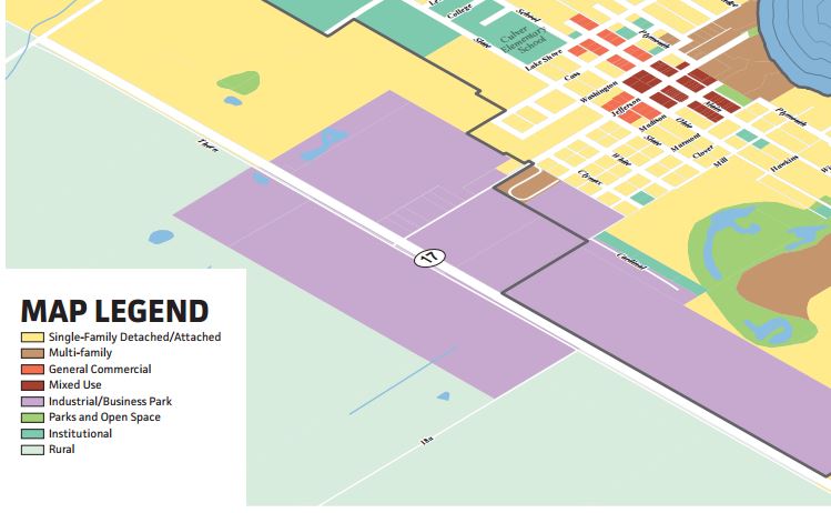
Let’s start with the Comprehensive Plan. The Future Land Use Map shows this block on Main Street as Mixed Use: “Mixed Use development is characterized as multi-story structures with retail, restaurant and service uses on the ground floor and office or residential uses on the upper floors where appropriate.” (pg 45) In the downtown district there are multiple references to the maintaining the “streetwall”, in general would imply a C-1 Zoning District.
The downtown, between Washington Street and Madison Street along Main Street, is zoned C-1. The block south of Madison Street is zoned C-2 on the east side and R-1 (with the exception of this recent rezoning) on the west side. Where this determination came from is somewhat puzzling since the description of the C-2 District in the Zoning Ordinance starts off: “The C-2 Commercial District is a general commercial district designed to serve free-standing commercial activities which may be highway oriented or those business establishments which by their nature do not readily adapt to a downtown location.” This area is obviously compatible with “downtown” since it is downtown and these businesses are in no way “highway oriented”. They also meet the requirements of maintaining the streetwall, though they do have off-street parking. So… this rezoning is a case of spot zoning, i.e. an island of C-2 in between R-1 lots. It is also contrary to the Comprehensive Plan which shows this area as part of downtown and suggests that it be C-1 to encourage the streetwall.
The adjacent property owner has legitimate complaints. 1) This will not enhance her property and will no doubt be detrimental to it as a residence which she hopes to maintain and 2) by making this a spot zoning and not rezoning the entire block as a commercial district she has not even benefited from the possibility of increasing the value of the property as a potential future commercial development site.
And to address the variance, the C-2 rezoning created this problem. C-1 has zero side yard setbacks, so this could have been moot on that basis.
I would argue that if rezoning was to occur here, the entire block should have been rezoned as C-1.
Parking:
There is some question in my mind regarding the need for additional downtown parking. Again, looking at the Comprehensive Plan I found the following references to parking:
Page 27, Business Surveys – “Proximity to home, parking availability, were identified as the greatest advantages for businesses [sic] owners.” Emphasis added.
Page 30, Desired Use/Development – “Other points identified developing vacant lots and underutilized parking lots in and around the downtown.” Emphasis added.
Page 45, Future Land Use, Mixed Use (definition) – “Mixed Use buildings should be located at or near the sidewalk with parking in the rear, so as to establish a consistent streetwall and foster a sense of activity. Emphasis Added.
Page 59, Commercial & Employment Areas Framework Plan, Mixed Use – “Parking should have a minimal presence along primary roadways such as Main Street and Lake Shore Drive.”
Page 60, Commercial & Employment Areas Framework Plan, Downtown Culver – “Buildings along Main Street should be at or near the sidewalk with parking at the rear.”
Page 62, Commercial Area Policies, Maintain the Streetwall in Mixed Use Areas – “The success of Mixed Use areas can be undermined if the streetwall suffers from large gaps between buildings, buildings that are substantially setback from the sidewalk, or parking area adjacent to the sidewalk with no perimeter landscaping, fencing or screening. In areas where gaps are unavoidable, a combination of landscaping, decorative fencing and masonry/stone walls should be used.:
And there are more references such as the section on creating Parking Policy on page 65 and the discussion of Complete Streets on page 94 continue to talk about avoiding parking lots on Main Street and encouraging on-street parking or parking in the rear. There are also sections that suggest parking be screen, include planting islands and trees for shade. None of which have been included in the plan up for consideration.
232 South Main Street from Comp Plan
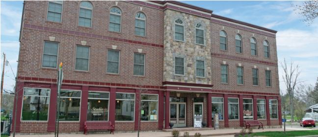
The parking lot proposal is a collaboration between the Town and the developer of the building at 232 South Main Street. At the public meetings it is being discussed as a public project and fulfilling a need for downtown parking. In actuality it seems to be more of a response to the relocation of the Lake Shore Clinic to 232 South Main Street and the perceived increase in parking needs. This is somewhat frustrating since prior to construction in 2007, the developer was granted a parking variance from ordinance standards. It would seem that if the building had included the required parking spaces this new lot would not be required. But doubly so, since as the Comprehensive Plan, just completed last year, discusses parking availability and underutilized parking lots as positives.
I would also question whether the proposed parking lot meets the Zoning Ordinance parking requirements, specifically 1) There shall be onsite stormwater detention (pg 54, Design and Maintenance #7) and 2) There shall be no parking in the front yard (pg 54, Design and Maintenance #11) While there are drywells called out on the plans, I would rather see an above ground detention structure that can be cleaned and maintained. Regarding the front yard, I had an interesting discussion with the Building Commissioner. He does not consider this property as having a front yard since there is not a building on it, but also noted that the setback is considered the front yard when looking at site distance in L-1. That also then brings up whether the parking lot is considered a structure, which it would be under the definitions on page 14, at which point it might again need a variance for violating the front setback. And then there is the impervious surface restriction. I’m not sure how they are going to keep less than 60% impervious surface with a parking lot that is only setback 12″ from the side lot lines. The Building Commissioners position is that parking lots are not defined in the Zoning Ordinance which means everything is up for interpretation by the Plan Commission. Fair point, but not particularly helpful heading into a hearing.
A couple of final thoughts I have. First, I would probably not be in favor of the variance request tonight (though I won’t speak against it). If the entire block had been rezoned, I would have been more likely to support it, but the spot zoning seems quite odd. The decision making seems a bit schizophrenic in that we’re shoehorning in a spot zoned commercial use, without making the commitment of expanding the surrounding residential area as commercial use. Second, I am very disappointed that the Comprehensive Plan was not consulted in this decision. I did not see it discussed in any of the above meetings and that’s unfortunate when the plan is not much more than a year old. True it is just a plan and as with all plans, subject to change, but my feeling is that it was ignored, not changed. Such is life in the big city… or Culver…
Culver’s Current Zoning Boundary in pink with the approximate 2-mile limit shown in the outer ring.
When I was driving down Hwy 117 the other day I noticed that Mystic Hills has added a couple of new buildings that I’m guessing are rental cabins. I’m glad they are doing well, but I was a bit surprised to see them as I hadn’t remembered any discussion regarding a site plan revision at the Culver Plan Commission. I wasn’t sure how the mixed use had been approved. Then I remembered… Mystic Hills is outside Culver’s Zoning Boundary.
It’s unfortunate, but the Plan Commission members (and me!) were fairly disheartened by the Town Council’s decision to overrule them on the wind turbine ordinance. Rightly so, they believe that this probably killed any chances of extending our territorial authority.
As the song goes, “I’m Living in a Box”. Maybe this is an answer to Culver’s Affordable Housing Crisis? I ran across this on the Viralands site. I’ve seen several different versions of Shipping Container Construction, many of them designed as affordable housing, including some that are multi-story which I showed here before. I think this is one of the more attractive ones though. There are more pictures at the site here.
Currently this would not fly under Culver’s Zoning Ordinance without a variance since the square footage would be too small. It would probably also spark a spirited discussion with the County Building Inspector since it wouldn’t fit neatly into current building codes. It is an interesting concept though and at the stated $2,000 for a used shipping container, it would be hard to beat that price for the shell of your new home. This would have to be some of the ultimate recycling as well, so it’s definitely green!
 I’ve written about the new parking lot slated for downtown Culver here and here, I had a somewhat heated exchange the other day regarding the parking lot and whether it was an issue that affected Lake Maxinkuckee. So here is my mini rant list on why this is an environmental issue: