On Tuesday April 30 I was invited to a meeting with Jackie Walorski at the Plymouth Chamber of Commerce. There was some interesting discussion (more than what was printed in the paper) but I was disappointed in the participation. I know that invitations were sent to the other Community Chambers and there were no other representatives there. Of those in attendance only three of us brought up issues for the congresswoman’s consideration, despite her obvious willingness to answer questions and work on issues. This was a follow up on a meeting she held at the Plymouth Chamber in January which I attended, and I have to say I was impressed that not only did she remember me, but she came back with answers to some of the questions I posed then.
There were only about four of us that put questions in front of the congresswoman and because of lulls where no one else asked anything, I actually put three in front of her. She was receptive and honest, when she didn’t know she said she would find out and get back to us. I don’t think we can ask for any more than that.
As much as I am disappointed in the goings on in Washington, I felt that the interest from Congresswoman Walorski was refreshing and was a counterpoint to the disinterest from those that bothered to come.
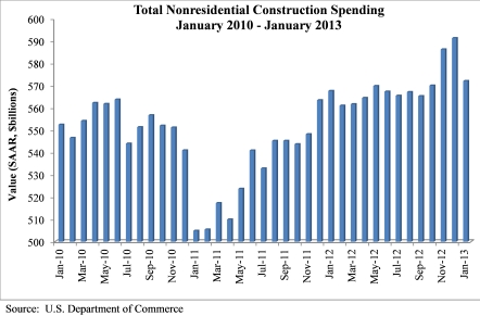
NONRESIDENTIAL CONSTRUCTION SPENDING FALLS 3.3 PERCENT IN JANUARY
As further evidence that the nation’s construction industry continues to struggle, nonresidential construction spending fell 3.3 percent in January, with outlays decreasing to a seasonally adjusted annual rate of $572.1 billion, according to the March 1 report by the U.S. Census Bureau. Year over year, total nonresidential construction spending is up only 0.8 percent (unadjusted for inflation).
Both private and public nonresidential construction spending were down for the month. Private nonresidential construction spending fell 5.1 percent on a monthly basis, but is 4 percent higher compared to one year ago. Public nonresidential construction spending declined 1 percent in January and is 2.7 percent lower than January 2012.
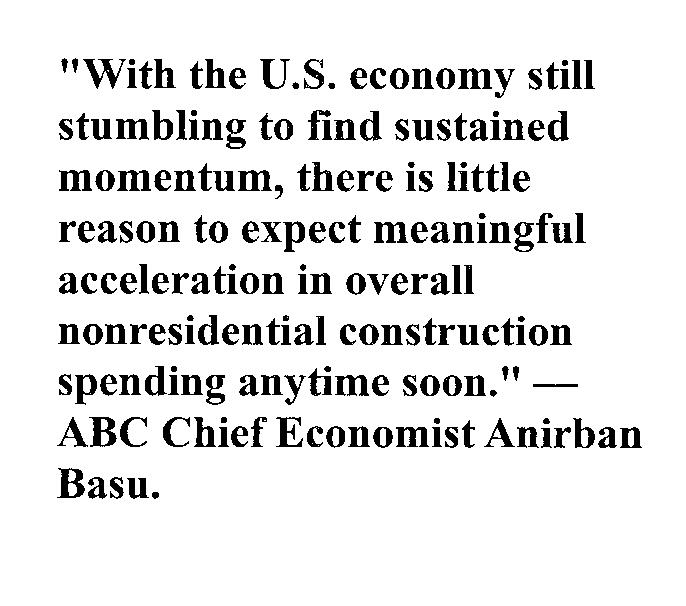
“January’s construction spending decline was particularly alarming because the loss in momentum spread deep into privately financed categories,” said Associated Builders and Contractors Chief Economist Anirban Basu. “In previous months, decreased spending in a number of public spending-oriented sectors like sewage and waste disposal and public safety was roughly counter-balanced by increased spending in intensely private segments, such as power and manufacturing.
“That changed in January, with privately financed segments like power and manufacturing reversing course and experiencing substantial monthly declines in construction spending” said Basu. “The upshot is that nonresidential construction spending is virtually unchanged over the past year.
I shared some of my rants regarding the changes to the zoning boundary with Jeff Kenney of the Culver Citizen and he suggested that I send him a letter to the editor on the subject. I am a little freer with my writing here in the blog since I know my audience is different, so I wrote a separate Letter to the Editor and cleaned up my prose a bit. Hopefully it will encourage people to get involved and do some of the research themselves. My earlier piece included all of the links and drawings, so I’ve made it easy for anyone to follow my research. What do you think?
PS – If anyone can tell me why I lose my paragraph breaks on text I cut & paste into a post, let me know! Drives me nuts! It looks right in the editor and then loses the spaces between paragraphs when it posts… I guess I’ll go old-school and add indents…
I went home pretty frustrated last night. I had shared my previous post on the Two Mile Zoning Boundary with the Town Council and Plan Commission last week. I am also on the Steering Committee for the Plymouth Comprehensive Plan review and attended that meeting Monday evening. (6:00 until 9:45! Sheesh!) The topic of the Two Mile Zoning Boundary came up and there was a lively discussion. Yesterday I sent the following email to the Town Council and Plan Commission ahead of the Plan Commission meeting last night:
All,
I attended last night’s Plymouth Comprehensive Plan review on behalf of MCEDC. One of the items that Jackie Turner with Ratio Architects had in the draft plan was ceding some extra territorial control back to the County. I questioned why this would ever be considered as the extended territorial control was there to allow the municipality to control its destiny. She replied that if Plymouth was looking at the plan as a 10 year document, then they might want to divest themselves of the burden of supervising areas that weren’t planned for annexation in the next 10 years. I asked why a municipality would EVER want to cede control to the county and shouldn’t our vision be for 50 years, not just 10? I then asked about problems with residential development surrounding industrial areas making expansion difficult, the problem with subdivisions just outside the territorial boundary which used services, but did not pay for them (fire, police, parks, etc.) and and the difficulties of leapfrogging areas that had been developed that resisted annexation to serve new development or other older developments that needed services. This started a rather spirited response from Plymouth departmental staff naming specific instances where this is already a problem.
Ms. Turner agreed with my points for the most part, saying she was just giving that as an option to be considered as part of the comprehensive planning process. She said there still may be areas of no growth where Plymouth might want to consider this, but all the points I made need to be considered before making that decision.
I’m paraphrasing the discussion above, but I double checked it with Brent Martin who was also in attendance. Ralph Booker was there also. One of the big points I think Culver should take from this is that determining the extended territorial boundary is a discussion that should be had as part of the Comprehensive Planning process. There is no reason that we can’t put this off until our planning process is complete.
Kevin
After sending that out yesterday, I had a meeting with the representatives from Houseal Lavigne Associates who were here doing interviews to start our Comprehensive Plan project. I was there representing MCEDC. As part of our discussion, I laid out the scenario of the property swaps to Devin Lavigne and he agreed with me that it probably was not appropriate to give up any control since it was so hard fought to obtain. He also agreed that this should be part of the comprehensive planning process we were just beginning.
At the Plan Commission last night Ralph Booker, Marshall County Plan Director, presented the maps including a calculation of the acreage of the land that was swapped. Ralph Winters, Plan Commission Chairman, called for a vote without audience input and it was passed without discussion. My arguments were not mentioned. Our new planners, sitting in the audience, were not consulted. Opportunity missed. Do you like the Face Palm GIF? That was me last night!
Passing this last night puts it in front of the Town Council for approval. I’m not sure when that will happen or whether the Town Council will buck the Plan Commission on this again.
The Marshall County Plan Director, Ralph Booker, and Marshall County Building Inspector, Chuck DeWitt, have been working on a system where all of the building permits for the County can be completed through the Marshall County website using the GIS (Graphic Information System). It has been approved by the Culver Plan Commission and was approved by the Culver Town Council at their meeting on February 12th. An issue arose where throughout the County there are multiple properties that are split between a County Zoning District and the various Municipalities’ Zoning Districts. As usual, Culver is the worst case scenario with more split properties than any other Marshall County community. This is a problem since the building permit program would like to address zoning issues in building permit applications via parcel ownership. (You can see a map showing Marshall County and the zoning boundaries of all the communities here.)
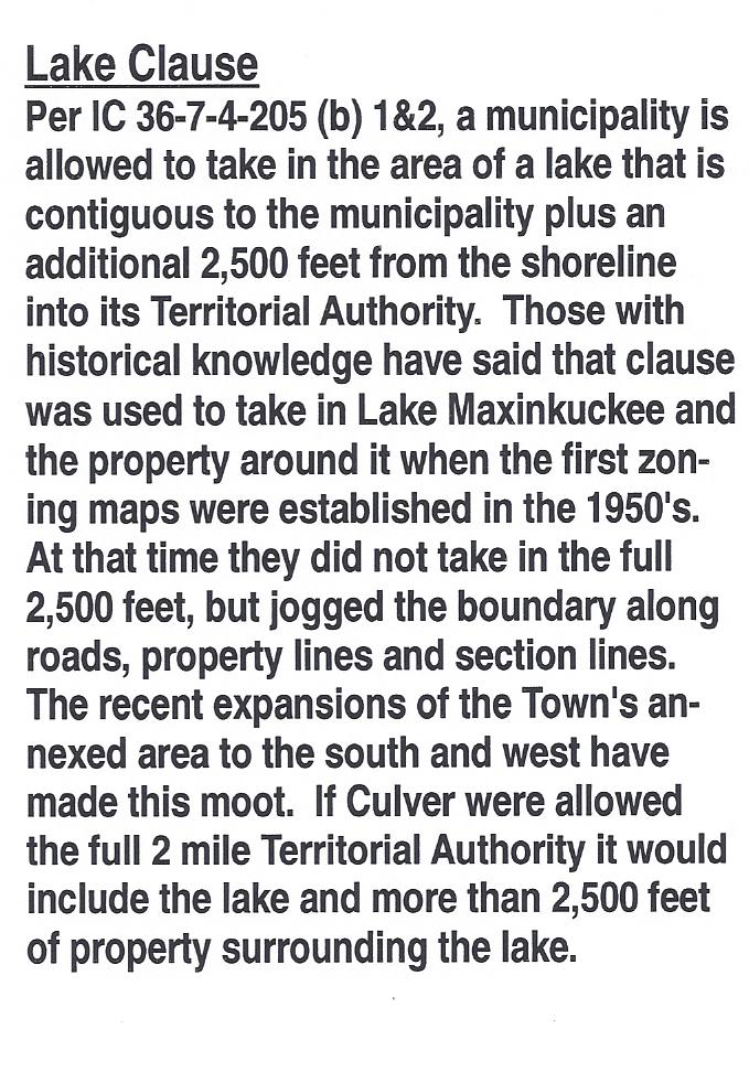
By Indiana State Statute IC 36-7-4-205, municipalities are allowed to take in contiguous unincorporated areas outside of their annexed municipal limits as extended Territorial Authority via their Comprehensive Plan. This is often referred to as the “two mile zoning boundary” as that is the maximum allowed by statute. Even though it is often referenced as the Two Mile Zoning Boundary in discussions at the Culver Plan Commission, and it is labeled that way on the map on the wall, Culver has never had the entire allowed area. In the case of municipalities such as Culver which are adjacent to lakes, the municipality is allowed to take in the lake and the property surrounding it. (See comments on the clause regarding lakes excerpted to the right.)
My understanding is the premise of this statute dates back to the growth spurt Indiana and the rest of the nation experienced after World War II. Often that growth occurred in the fringe areas around municipalities in a chaotic manner. In most cases there was no county zoning at the time, so Indiana and other states granted their municipalities the extended territorial authority to apply zoning standards to the fringe areas. This extended authority varied by state and I found examples of it extending from 1 to 4 miles outside municipal boundaries. In the case of Indiana, most counties have zoning ordinances now, but the extended boundary is still used by communities to control the area of imminent growth at their perimeter. Imminent growth around Culver is probably something that I’ll hear arguments about. In this case “imminent” needs to be judged by the life of our community, not by our short personal lifetimes. Imminent for Culver should be looked at through the lens of the future, looking forward 2o or even 50 years.
At the time the current zoning boundary was created, Culver was actually pretty progressive and was one of the first communities in Marshall County to establish a Plan Commission and a Zoning District. According to Pete Trone and Bobbie Ruhnow, my planning and zoning historical references, Culver took partial advantage of the territorial authority allowed and included Lake Maxinkuckee in its zoning district. The Plan Commission did not take in the full two miles at the time because they didn’t want to clash with the farm community. Since there was no County zoning at that time, there were no restrictions placed on the farmers outside the municipal limits. In most areas the lines were drawn along section lines or from intersections without regard for parcel lines. Thus the “problem” with the split parcels. This issue exists mainly on the west and north. Parcels were generally used to draw the line around the lake, so the east and south boundaries are clearer. You can see a detailed map of Culver’s zoning boundaries here.
Culver’s Zoning Boundary The pink area shows the current extended authority. The loop outside that shows the approximate limits if the Two Mile area was granted.
In meetings with the Culver Plan Commission, it has been presented that the GIS system at the County is based on the parcel lines and since the zoning boundary lines around Culver do not follow parcel lines, the transitions between zoning boundaries are too difficult to determine. Admittedly, I am no expert in the nuts & bolts of the County GIS system. I am confused though how this can be such a difficult issue when the system currently shows soils maps, flood zones, etc. which bisect parcels and cross parcel lines with curvilinear representation. The current plan is being promoted as “fair” because it takes the majority of the split parcels and puts them completely under Culver jurisdiction if more than 50% is currently under Culver jurisdiction. If less than 50% is currently in Culver jurisdiction the entire parcel will be placed under Marshall County jurisdiction. While this is ostensibly “fair”, fairness is not the reason for the two mile boundary. The two mile zoning boundary is provided for by the State so that a municipality can control its destiny. Theoretically municipalities will continue to grow. Culver should plan to grow! In economic terms, communities are either growing or dying. There is no Status Quo!
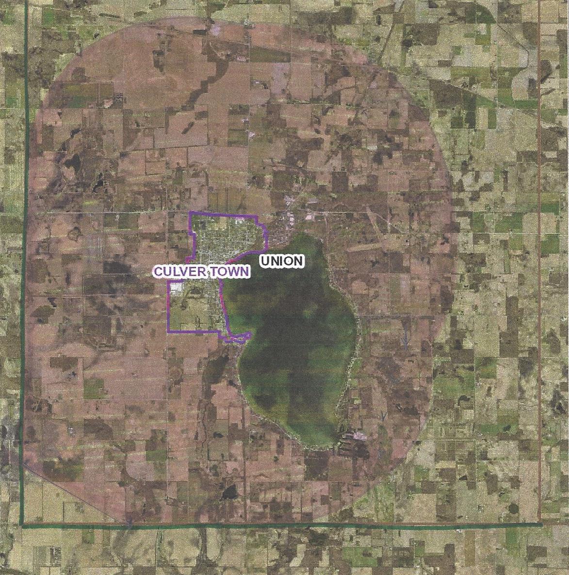
Potential Culver Zoning Boundary There area in pink is roughly drawn two miles out from radii at the extents of the Town boundary
Culver currently does not have the full two miles allowed in any direction. So why are we giving up control of any of our current area? Wouldn’t a more prudent solution to the GIS “problem” be to give all of the split parcels over to Culver’s control? While I’m not opposed to following parcel lines for convenience, I don’t think that should mean that we lose any parcel that crosses the current line. With a two mile extended authority our boundary would look more like the drawing to the right. If we take in every parcel that is split by the current boundary, we would still be well within the two mile limit. If that’s not acceptable, then I think the current boundary line should remain as is. As per my reference to the soils and flood plain layers, I think the GIS is versatile enough to illustrate those things. If there’s a discrepancy; bring it to the Plan Commission for a determination.
* Thanks to Pete Trone and Bobbie Ruhnow – both provided historical reference and valuable input to my research.